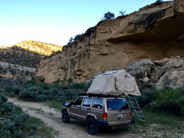
My surprisingly sublime campsite at first morning light.
Part 1 and Part 2 of this series set the stage.
I like to call Utah the “The Slanted Lands”. Everything seems just a little tilted, angled on a different plane.
Capitol Reef National Park is the poster child for this wonderfully disorienting axial shift, and I was headed there on the next-to-last day of my journey home from Overland Expo.
For the second night on this trip, I had driven myself into a situation where I was forced to grope around in the dark for a campsite; and for the second time, morning revealed a pretty magnificent result.
Not bad for stumbling into it blindly in the dark.
What I didn’t know for sure then, but do now, is that this amazing campsite, not marked on any map, and countless others may soon be off limits to you and me.
Nearly all the predictions I had made only one year ago about the Trump administration’s intent to divest Americans of their public lands is now coming to pass. On Monday in Salt Lake City, Interior Secretary Ryan Zinke and the President are set to announce huge reductions of both Grand Staircase Escalante National Monument and Bears Ears National Monument, among others.
My friend Pat summarizes the changes. The Department of the Interior maps obtained by the Washington Post show a disastrous shattering of red rock country. The proposal is nothing short of devastating for Utah wilderness:
- Bears Ears is shrinking from 1.35 million acres to 201,397 acres (85%)
- Grand Staircase is shrinking from 1.9 million acres to 997,490 acres (50%)
Bears Ears will become two smaller Monuments called
- Sasha Jaa
- Indian Creek
Grand Staircase will become three smaller Monuments called
- Grand Staircase
- Kaiparowits
- Escalante Canyons
This is particularly ruinous for Grand Staircase, which generally has been managed as a complete large ecosystem since the 1990s. A pipe dream of a coal mine on the Kaiparowits Plateau long cherished by mining companies will likely come to pass. Roads and trails will close, wilderness areas will fragment, cultural and paleontological sites will be subsumed. Access to your public lands will be denied.
As I argued last year, we will become land poor.
There is still action you can take. Contribute to organizations that defend wild nature in Utah and elsewhere, call your representatives (better yet, vote new ones into office), support the Native American Tribes and others who are gearing up to fight these proposed changes in court. It’s not too late, but it will be soon.
***
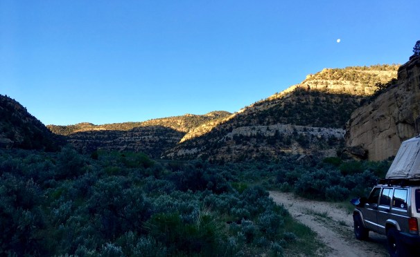
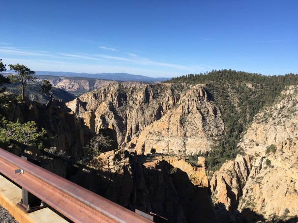
Who knows? This may be the last time I camp in this place, drive these roads. On that morning in May, there was little time to linger over lazy cups of coffee – I was determined to secure a good campsite in Capitol Reef (before it got dark), and also give myself plenty of time to explore the back roads of the Park’s Cathedral Valley unit.
I rolled into sleepy Escalante just past dawn, topped off the tank, bought the first cup of joe sold that day at the gas station, and turned north toward Hell’s Backbone.

The birches were just coming into their leaves at 9000′ on Hell’s Backbone.
Utah State Route 12 is possibly my favorite stretch of tarmac in the world – the road connects Escalante to Torrey, Utah via the small hamlet of Boulder Town. The ecosystems and scenery it transects have no rival. If you are ever presented with the chance, you must not miss it. I put it up against any highway anywhere in the world for its sheer beauty.
But, my goal was to stick to dirt roads – so I chose Pine Creek Rd/USFS 153 up and over Hell’s Backbone. Thousands of feet of elevation change would greet me over the tracks blazed by the Civilian Conservation Corps in the 1930s. USFS 153 was the old connector between Escalante and Boulder, an alternate America.
Near the top of the pass on Hell’s Backbone.
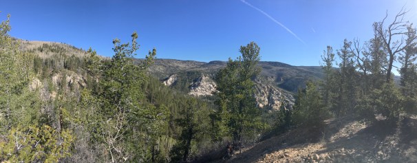
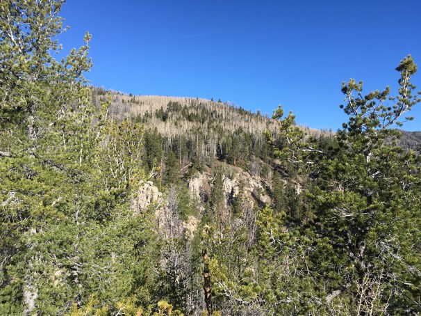
Hell’s Backbone tops out at 9000′ in elevation. The road is well-maintained, so no particular off-road challenges were expected – but this route shows off what makes Utah so spectacular. The ever-varying and diverse landscapes that you can traverse in a single morning are mind-boggling.
Utah’s grand diversity of landscapes.

Vogue.
The single-lane bridge that links the east and west halves of Hell’s Backbone is the engineering pièce de résistance on the route. First built as a timber span by the CCC, the canyon walls plunge 1500 feet from either side into the depths of the Box-Death Hollow Wilderness.
Even now, with the bridge long replaced by asphalt and steel, the 100 foot distance still feels sketchy.
The one-lane bridge near the summit of Hell’s Backbone.
John Wesley Powell, on his second survey of Utah’s Paitue Indian lands in 1872 sent a party up and over this high pass. Wallace Stegner describes the scene in Beyond the 100th Meridian: John Wesley Powell and the Second Opening of the American West:
“It is a perfect paradise for anybody – still is. The present road from Escalante to Bicknell across the southern shoulder that [Powell’s party] was traversing in 1872 is the only one. Until 1929, the town of Boulder on its roof got mail by pack-mule. The Hell’s Backbone Trail that branches off to serve Boulder now would bring the lights of most drivers clear to the roof of their mouths. Until Jeeps started taking fishing and hunting parties in about 1946 there had never been a wheeled vehicle on much of its northern end. Wooded clear across its 11,500 foot top, studded with a hundred lakes, it offers from any part of its periphery not only the charm of its own mountain scenery and climate, but views to take the breath: southeastward to the Henry Mountains on the edge of the Colorado; southwestward over the desert to the knife-edge of the Kaiparowits; northeastward across the toothed comb of the Waterpocket Fold to Thousand Lake Mountain climbing from its red base courses to its crest of dark lava and spruce.”
It was Mother’s Day, so if I was going to be a good son, I would need some cell service eventually, and it’s not always easy to find in this part of the country.
But I was still committed to my dirt-exclusive route planning. After reaching the end of the Hell’s Backbone road, rather than tack north on Highway 12 over the Boulder Mountains to civilization, I took the Burr Trail east across the Waterpocket Fold, onto the Notom-Bullfrog Road, and kicked dust for Torrey, Utah.
In addition to a cell phone signal, Torrey also offered a fuel top-up and a handful of snacks. After calls and texts to my mother, grandmother, and mother-in-law, I beat tracks for my brass ring – Cathedral Valley.
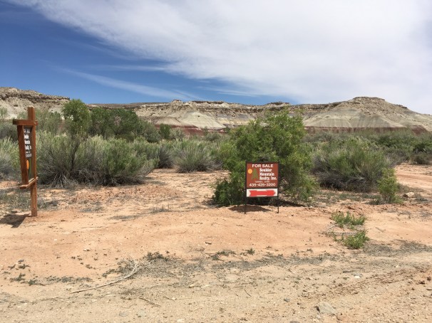
Property for sale near the Fremont River ford. We could be seeing a lot more of this.
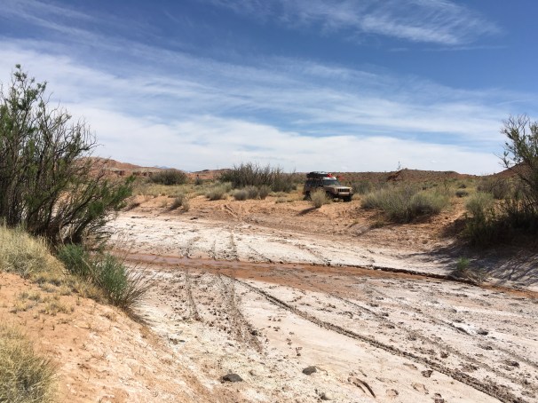
Famously, the southern entrance to Cathedral Valley fords the Fremont River just west of Caineville, Utah. The river never really gets too deep (except during flash floods), but the heavy run-off from a hard winter had carved a decent channel along the north bank.

Fremont River ford – the entrance to Cathedral Valley.

The ford.
Only one way to find out:
I fully admit to running the river four times. I’m not proud.
A few miles north of the ford brought me to the Bentonite Hills – a denuded and alien landscape that geologically links the slanted sandstone lands of the Waterpocket Fold with the towering buttresses of the Cathedral Valley.

Alien landscapes in Cathedral Valley.
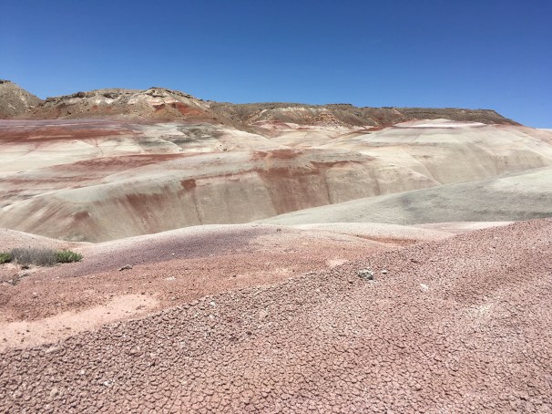
Bentonite Hills.
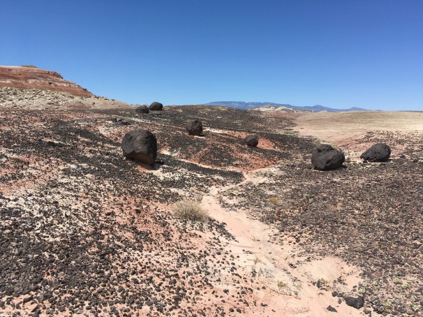
Erratic boulders – Cathedral Valley.
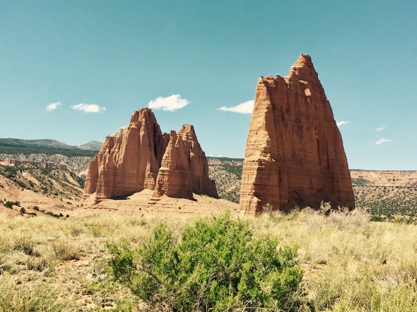
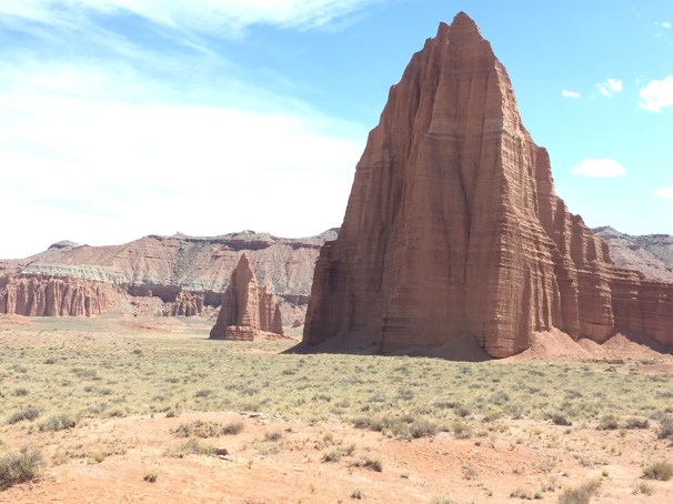
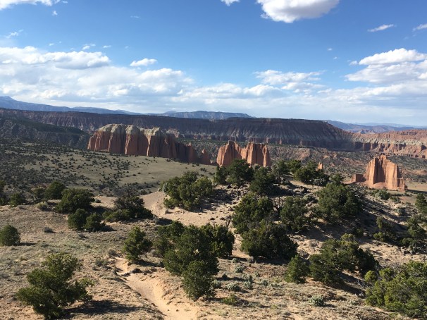
Cathedrals.

Cathedral Valley.
Despite having visited Capitol Reef National Park many times before, I had never traveled to this most northern part of the Park. One of its great features is how Hartnett Road and Cathedral Road – the two main paths through the Valley – intersect a dozen or so BLM roads that lead you deeper and deeper into the wilderness. The opportunities for exploration reach in all directions.
Two roads that do manage to stay within in the National Park lead you to the Gypsum Sinkhole, the Glass Mountain, and the Temples of the Sun and the Moon. If you’re not curious about those landmarks just from their names alone, you’re probably reading the wrong blog.
Around one bend I noticed a distinct slot in one of the cliff faces and stopped to investigate.

I wonder what’s in there…
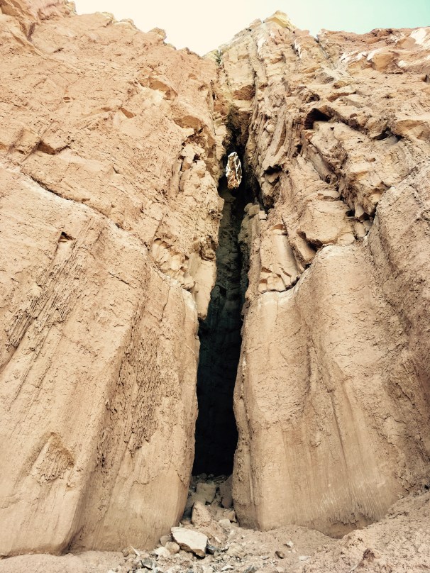
A pour off!
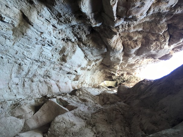
I was a little concerned that rocks or other debris would come cascading down…
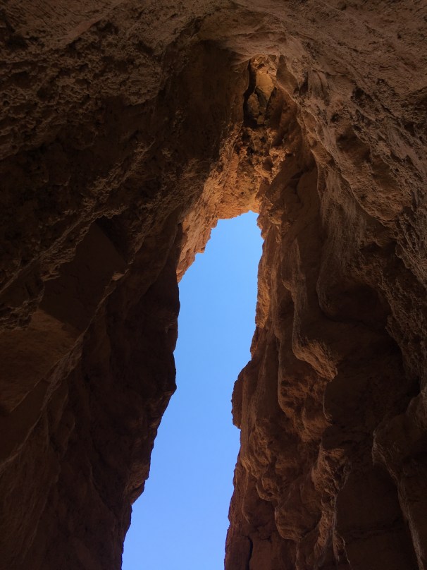
But not for long. Utah skies.

Hayduke the Golden Bullet.
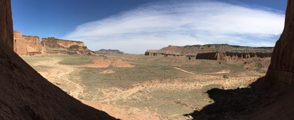
Cathedral Valley pano.
The Gypsum Sinkhole did not disappoint. It looked like something straight out of Star Wars. It’s not readily apparent where it’s located, and you don’t see the 200 foot deep pit until you’re right on top of it.

The Great Pit of Carkoon, waiting for the Almighty Sarlacc to appear.

Juniper fence posts, Cathedral Valley.

On the road in Cathedral Valley. The photo looks tilted, but it’s really the landscape.

An imposing formation – Cathedral Valley.
Further exploration led me to the Glass Mountain and the The Temples of the Sun and Moon.
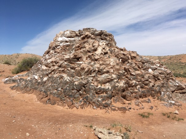
The Glass Mountain – a concentrated formation of gypsum crystals, Cathedral Valley.
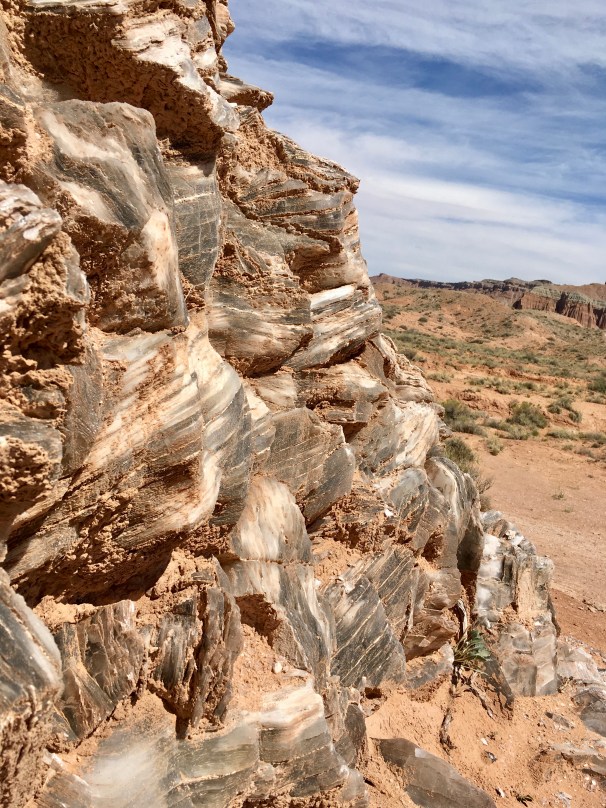
Glass Mountain, close up.
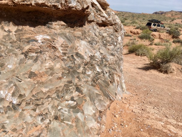
The Glass Mountain.
Temples of the Sun and Moon.
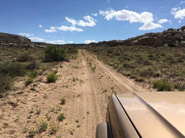
Cathedral Valley Road itself is not particularly challenging – I saw two Subaru Outbacks and one Nissan Maxima navigating it with ease (you don’t have to do the river ford to access the Valley), so it was now time to tread on lesser traveled paths.
Let’s let the pictures do the talking:

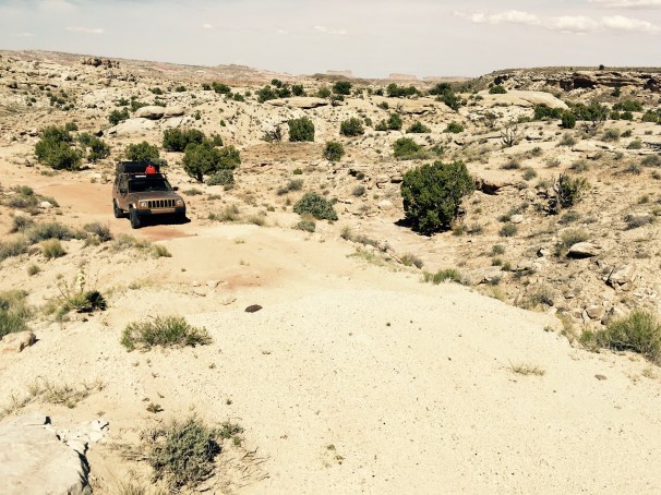
A side road not traversed in a very long time.
The end of this particular road – a muddy wash that intersected a different BLM track. I braved the mud only on foot.
Cutting across an alternate track that would lead me to my campsite.

Some rock work ahead.

Navigating the sand and slickrock.
Moving patiently.

More obstacles dispatched.

The roads less traveled often lead to remarkable things.

Carefully.

The Golden Bullet in its element.

Cactus flower, Cathedral Valley.

More moonscapes.

This is one happy Jeep.
I had already staked out my claim to a campsite in the National Park’s Cathedral Valley Campground earlier in the day, and after a solid afternoon of adventure, I returned well before sunset to enjoy the silence and the solitude. I had the entire campground, it seemed like all of Utah, to myself.
The views from my campsite were pretty excellent.

Cathedral Valley
I look forward to returning to Cathedral Valley to dig further into its secrets – one day was not nearly enough given all the alternate tracks spinning off its main road. I think it may be one of my favorite corners of Utah now, and that’s saying something.
I had a bit of a celebration on my last night alone in the wilderness – a decent steak grilled medium rare over the fire with cracked black pepper and butter, paired with a Lumberyard (Flagstaff, AZ) IPA. I even ate a couple of veggies.
The night was – I admit it – lonely. And strangely quiet.
There were no birds at this campsite, no jays or crows or nuthatches to share my stories with. Just me and the Utah desert unfolding below. The scrub pines, the juniper and the sage all stilled themselves after the last of the evening breeze, and I climbed into the tent.
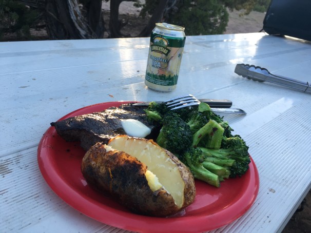
A final gluttonous send-off before the long cruise back home. Cathedral Valley Campground, I will see you again.
***
In Scipio, Utah (population 290) I stopped for gas. The credit card readers on the pumps were out of order, so I walked into the fluorescent convenience store to pay in advance for my fuel, to pay in advance for my return home.
The clerk behind the desk was a woman whose age I could not easily guess. She might have been 25, she might have been 40. She had rings on each finger, and she muttered curses at the register. I read “Sherry” on her name tag.
My mind was back in Cathedral Valley, replaying in frame-stop motion the herd of Mule Deer that bolted across the road in front of me as I drove up and out from the valley, into the snow-bound mountain passes once again, draining inexorably down to the Interstates, and to the world.
“Where are you coming from?”, she asked.
“I was just in Capitol Reef. I took the backroads, an alternate route.”
Rings flashing, snagging my credit card, “By yourself?”
“Yeah. I’m all alone on this trip.”
“Boy, I love it down there,” she said. “If I could get a weekend just for me, by myself, I don’t even know what I’d do with it.”
“Why don’t you?”, I asked.
Looking into the middle distance, Sherry sighed, “Oh, we’ve got four kids, my husband wouldn’t know what to do with any of them if I left for more than a day. Still, I know that country, and I know how to handle a Jeep. Maybe I will go.”
The register drawer jumped open, and my receipt chattered in the printer.
Maybe I will go.
Maybe you will go.
Go now before you can’t go at all.

I just re-read all three parts. Such a good report Steve, just makes one want to DO the adventure!
Having the summation of the political issues while travelling through the actual land, really brought it home too. Even as an outsider.
Keep up the good work mate!
LikeLiked by 1 person
Thanks, man! I really enjoyed writing this series.
LikeLiked by 1 person